Marangu Route — 5-Day Kilimanjaro Trek
Places Kilimanjaro
Known as the “Coca-Cola” route, the Marangu route is a classic trek on Mount Kilimanjaro. It is the…

Africa's highest point, climbable without technical gear


Kilimanjaro National Park sits in northern Tanzania, near the town of Moshi. It covers 1,668 square kilometres (641 square miles).
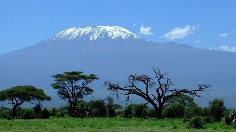
At 5,895 metres (19,336 feet), Kilimanjaro is the highest mountain in Africa and the tallest free-standing mountain in the world. It has three volcanic peaks: Kibo, Mawenzi and Shira. It looks impossible because of the ground it rises from. That is coastal scrubland at about 900 metres, with nothing else nearby to compare it to.
Nobody is certain what the name means. Mountain of Light, Mountain of Greatness and Mountain of Caravans have all been suggested. The local people, the Wachagga, have no name for the whole massif. They only name Kipoo, now known as Kibo, the snowy peak everyone recognises.
Getting there is straightforward. The park is 128 km (80 miles) from Arusha, and about an hour's drive from Kilimanjaro airport.
Most people come to climb. There are six usual trekking routes to the summit, plus harder mountaineering lines for experienced climbers. But you don't have to go to the top to enjoy the mountain. You can walk on the Shira plateau for a day or stay overnight, follow the nature trails on the lower slopes, fish for trout, or visit the Chala crater lake on the south-eastern side.
If you are going for the summit, climb slowly. Allow at least five nights, and more if you can. The extra time gets you to the top. It is the single best thing you can do to avoid altitude sickness.
Kilimanjaro is a free-standing volcanic massif, not part of a range, which is why it looks the way it does from a distance. Snow and ice sitting above open plains barely three degrees from the equator. At 5,895 m it's the highest point in Africa and the highest free-standing mountain in the world.
It is also, uniquely among the great peaks, a walk, not a climb. No technical skill or equipment is required on the standard routes. That doesn't make it easy. Altitude is the real difficulty, and the single largest factor in whether a trek succeeds is how many days it spends acclimatising. Routes differ mainly in that profile, in how busy they're, and in whether you sleep in huts or tents.
Places Kilimanjaro
Known as the “Coca-Cola” route, the Marangu route is a classic trek on Mount Kilimanjaro. It is the…
Places Kilimanjaro
The Marangu route is one of the most popular routes to the summit of Kilimanjaro.
Places Kilimanjaro
Six days on the Machame route, camping throughout. The shortest Machame itinerary, with a steeper daily…
Places Kilimanjaro
Seven days on Machame, with the Barranco to Barafu leg split over two days, so the day before the summit…
Places Kilimanjaro
The Rongai route is the only route that approaches Kilimanjaro from the north, close to the Kenyan…
Places Kilimanjaro
Eight days on the Lemosho route, starting in rainforest on the mountain's western side, with the longest…
The trek passes through several vegetation zones in turn: rainforest, heath and moorland with giant lobelia and groundsel, alpine desert, then the summit zone. Wildlife is limited compared with the parks: blue monkey and colobus in the forest, plus birds. People come for the mountain and the zones, not for game.
Trailheads sit around the mountain and are reached by road from Arusha or Moshi. The migrated park information gives the distance from Arusha as 128 km (80 miles) and around an hour's drive from Kilimanjaro International Airport.
January to mid-March and June to October.

Kilimanjaro is the highest free-standing mountain in the world and the highest point in Africa, at 5,895 metres. The thing that matters most to a visitor is that none of the standard routes need technical climbing. No rope, no ice axe, no mountaineering experience. It is a walk. A very long, very high walk, but a walk. That is why about thirty thousand people a year attempt it.
That same accessibility is where the danger comes from. Because there is no technical barrier, people arrive underestimating the barrier that is real, which is altitude.
How many days you spend going up almost entirely decides whether you reach the top. Fitness matters far less. Marathon runners fail on five-day trips. Ordinary, reasonably fit people in their sixties reach the summit comfortably on eight-day ones.
The climb takes you through five different ecological zones in a few days, and there are very few places on earth where you can do that. You start in farmland. You walk up through dripping montane rainforest with colobus monkeys overhead. You come out into heather and giant lobelia moorland. You cross a high alpine desert of volcanic rubble where almost nothing grows. And you finish in an arctic zone of glacier and scree. It is like walking from the equator to the poles in under a week.
The summit is the rim of a volcanic crater. Uhuru Peak is the highest point on that rim. The glaciers you pass on the final approach are what is left of a much larger ice cap, and they are visibly shrinking.
Dry Shoulder Green Long rains
One of the two best months. Warmer than the northern-summer season, quieter on the trail, and more likely to give snow on the summit, which most people find makes the summit morning better.
The other pick of the year. Clear, relatively warm, and quiet. Many guides prefer January to mid-March over the busier June-to-October window for exactly these reasons.
Good in the first half, deteriorating in the second as the long rains approach. Book the early part of the month, not the end.
The long rains. The forest zone is genuinely miserable, the Barranco rock is slick, and the summit is usually in cloud. Prices fall sharply. Not a sensible first climb.
Still the long rains and still not recommended for a first attempt. Experienced trekkers who don't mind wet forest will have the mountain close to themselves.
The dry season opens. Conditions improve through the month, the trail isn't yet crowded, and nights begin to get properly cold.
Dry, clear and busy. Machame and Marangu carry serious traffic. If you want space in this window, take Rongai or Lemosho.
The busiest month on the mountain. Excellent conditions and the coldest nights of the year. Book several months ahead, and further for dates near a full moon.
Dry, clear and slightly quieter than August. One of the strongest months overall.
The last of the main season. Good conditions early, with the short rains arriving toward the end of the month.
The short rains, usually afternoon showers, not all-day rain. Often perfectly climbable and much quieter. Rongai, on the mountain's dry northern side, is the sensible route this month.
Variable early and busy late. The first three weeks are quiet and often fine. The holidays fill the trail and the rates rise.
Days on the mountain. This is the biggest single factor by a long way. The five-day Marangu has the lowest success rate of any standard route. Seven- and eight-day trips on Lemosho and Machame have the highest. Every extra night is another night of getting used to the altitude, and nothing replaces it.
Walking slowly. "Pole pole" is not a local pleasantry. It is the method. Walking at a pace that feels absurdly slow at 3,000 metres lets you still be walking at 5,500.
Drinking. Three to four litres a day, on purpose, whether or not you feel thirsty. Being dehydrated looks like altitude sickness and makes it worse.
Altitude illness is a medical problem, not a fitness problem. Headache, nausea, dizziness and breathlessness while resting must be reported to your guide straight away, not pushed through. Going down is the only reliable treatment. Talk to your own doctor about any medication, including acetazolamide, well before you travel. Not to a guide, and not on the mountain.
TANAPA charges park fees per person per day, and they are the largest single part of what a climb costs. A quote that is dramatically cheaper than the others is usually cutting crew wages or days on the mountain. Both show.
Tell us how long you have and we will build an itinerary around it.