Safaris
Kilimanjaro
Destinations
Experiences
Travel guide
About
Contact Call +255 764 006 061 Plan Your Safari
7 days, 6 nights

Rongai Route — 7-Day Kilimanjaro Trek

The only approach from the north, and the quietest trail

The sun setting behind a jagged peak, seen from high on the mountain's snowy slopes.
Climbers scrambling up a steep rock step, using their hands and poles.
Green and yellow tents in a high camp below the snow-streaked summit of Kibo.
Two climbers in red and green jackets on a snowy slope above the clouds.
A giraffe on the plains with Kilimanjaro's snow-capped summit rising above the cloud behind it.
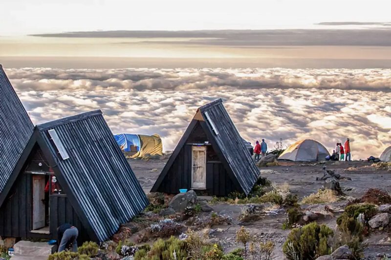
Wooden A-frame huts on a bare ridge above a sea of cloud.
Overview

Rongai is the only route that climbs Kilimanjaro from the north, near the Kenyan border.

It is getting more popular, but it is still quiet. People choose it for three reasons. They want an alternative to the crowded Marangu route. They want a more remote walk. Or they are climbing in the rainy season, and the north side of the mountain gets less rain.

You can do Rongai in six days. Seven is better, and that is our recommendation.

The scenery is less varied than on the western routes. Instead you get real wilderness. You walk for days without seeing much sign of anyone before the path joins the Marangu route at Kibo camp. You then come down the Marangu path.

Rongai is moderately hard. It is a good choice if you have not done much walking or camping before.

Day by day

The itinerary

Arrive in Tanzania Day 1

You arrive at Kilimanjaro International and transfer to Moshi or Marangu for the night. Rongai starts on the far side of the mountain, so tomorrow begins with a long drive round to the northern side near the Kenyan border, about three to four hours. That is why this route has an arrival day built in, instead of starting at a gate an hour from town. Use the evening for the briefing and the kit check. You can hire anything you are missing in Moshi, but not once you have left for the north. This is the moment to be honest about what you have and what you do not.

Nalemoru Gate to Simba Camp Day 2

The drive round the mountain to the Nalemoru gate at 1,990 metres takes the morning. Stay awake for it. It runs through Maasai grazing land and coffee and maize farms on the northern slopes, with the mountain on your left the whole way. The walk itself is gentle. Three to four hours through farmland, then pine and cypress plantation, then montane forest, climbing to Simba Camp at 2,625 metres. This is the driest side of Kilimanjaro. The forest here is thinner and less waterlogged than on the southern approaches, and the chance of walking the first day in rain is much lower. Buffalo and elephant are sometimes seen on the lower northern slopes.

Elevation1,990m → 2,625m
Simba Camp to 2nd Cave Camp Day 3

A steady climb out of the forest and into open moorland, from 2,625 metres to Second Cave Camp at 3,480. About six to seven hours. The northern side is drier and more open than the south. The views are out toward the Kenyan plains instead of into cloud, and there are far fewer people on the path. Rongai carries a fraction of Machame's traffic, and on a quiet week you can walk for hours without seeing another group. Kibo is ahead of you almost the whole way. The height gain today is large, and this is where most people first feel the altitude properly. The pace matters, and the water you drink matters more.

Elevation2,625m → 3,480m
2nd Cave Camp to Kikelewa Camp Day 4

A short, gentle day, from 3,480 metres to Kikelewa Camp at 3,630. About three to four hours. On paper it looks like a wasted day. It is the opposite. A small height gain with a long afternoon at altitude is exactly what your body needs to adjust, and it is one of the reasons the seven-day Rongai schedule does well. The path leaves the main ridge and crosses the moorland, with the jagged spires of Mawenzi coming into view ahead. Kikelewa sits in a sheltered spot among giant senecio, and the afternoon is genuinely restful. Use it. Eat, drink, and walk gently around camp instead of lying in the tent all afternoon.

Elevation3,480m → 3,630m
Kikelewa Camp to Mawenzi Tarn Hut Day 5

A steep climb out of Kikelewa, through the last of the vegetation, to Mawenzi Tarn Hut at 4,310 metres. The hut sits directly beneath the spires of Mawenzi itself. It is three to four hours of hard walking and you gain a lot of height. Mawenzi Tarn is one of the most dramatic campsites on the mountain. It is a small glacial pool under a shattered volcanic peak, in a bowl that catches the light early and loses it early. Most itineraries include a short acclimatisation walk above camp in the afternoon. Do it even when you do not feel like it. Headaches are common at this height. Report them. Do not quietly take a painkiller and carry on.

Elevation3,630m → 4,310m
Mawenzi Tarn Hut to Kibo Hut Day 6

The crossing of the saddle, from Mawenzi Tarn at 4,310 metres to Kibo Hut at 4,700. Four to five hours across the high alpine desert between the two peaks. It is a wide, wind-scoured plain of volcanic rubble with almost nothing growing on it, and Kibo fills the view ahead. It is not steep and it is not long, but at this altitude it is tiring in a way the distance does not explain. You arrive in the early afternoon at Kibo Hut, which is where the Rongai and Marangu routes meet. Eat, drink, prepare your summit kit, and be in your sleeping bag by early evening. Sleep will be broken. Warmth and stillness are what you are after.

Elevation4,310m → 4,700m
Kibo Hut to UHURU PEAK & down to Horombo Hut Day 7

Summit night from Kibo Hut, starting around midnight. The path climbs scree in switchbacks past Hans Meyer Cave to Gilman's Point on the crater rim at about 5,685 metres. Five or six hours of the hardest walking on the route, in the dark and the cold. From Gilman's Point the rim path continues round to Uhuru Peak at 5,895 metres, about another ninety minutes, arriving near dawn. The descent is on the same scree, fast and hard on the knees, back to Kibo and then down to Horombo Hut at 3,700 metres on the Marangu side. It is a very long day. The final walk out to the Marangu gate follows the next morning.

Elevation4,700m → 3,700m
The detail

What's included

Included

  • Kilimanjaro National Park entry and camping/hut fees
  • Rescue fees as required by the park authority
  • Professional mountain guides, cook and porters
  • All meals on the mountain
  • Tents and sleeping mats (camping routes)
  • Transfers to and from the trailhead

Not included

  • International flights and visa fees
  • Travel insurance covering trekking to 6,000 m
  • Personal trekking gear and sleeping bag
  • Tips for guides, cook and porters
  • Accommodation in Arusha or Moshi before and after the climb
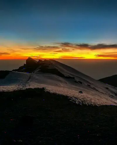
Sunrise from high on Kilimanjaro, an orange band above the cloud and snow on dark volcanic rock.
Is this right for you

The quiet route, from the dry side

Rongai is the only route that climbs Kilimanjaro from the north, close to the Kenyan border, and it is by far the quietest of the standard routes. On a normal week you can walk for hours without meeting another group.

The northern side is also the dry side. It sits in the mountain's rain shadow, so the forest section is far less likely to be walked in rain than on the southern approaches. That is a genuine advantage in the shoulder months of November and December, and it is the main reason Rongai is recommended for climbs outside the two dry seasons.

It suits climbers who want space more than company, anyone climbing in a marginal month, and anyone who prefers gentler slopes than the southern routes offer.

The trade-offs are real. Rongai's acclimatisation profile is less aggressive than Machame's. It is a steadier climb, without a pronounced climb-high, sleep-low day, although the short fourth day to Kikelewa does useful work. The scenery on the northern side is less varied than the south's. And the route comes down the Marangu path, so you finish on a different side from the one you started on, which makes the drive back longer.

Mawenzi Tarn, beneath the shattered spires of Mawenzi, is one of the finest campsites on the mountain.

Altitude

What actually decides whether you summit

Altitude decides who reaches Uhuru Peak, not fitness. Marathon runners fail on short schedules. Ordinary, reasonably fit people in their sixties reach the top comfortably on long ones. The thing that matters is how many nights you spend going up.

Walk slowly. "Pole pole" is not a local pleasantry. It is the method. A pace that feels absurdly slow at 3,000 metres is the pace that keeps you walking at 5,500. When your guide walks more slowly than you want, your guide is doing the job properly.

Drink three to four litres a day, on purpose, whether or not you feel thirsty. Being dehydrated looks exactly like altitude sickness, and it makes real altitude sickness worse.

The warning signs are headache, nausea, dizziness, loss of appetite and breathlessness while resting. Tell your guide straight away. Do not push through quietly. Guides are trained to judge this, and they cannot judge what you hide. Going down is the only reliable treatment, and turning back is a decision, not a failure.

Talk to your own doctor about any medication, including acetazolamide, well before you travel. That is not a conversation for a guide, and it is not one to have on the mountain.

Kilimanjaro's summit seen from the air, rising above a thick layer of cloud.
The crew

What your money pays for

A Kilimanjaro climb is carried by a crew several times larger than the climbing party. You will have guides, assistant guides, a cook and porters, and every day they move camp, water and food up the mountain ahead of you.

TANAPA sets the park fees. They are charged per person per day and they are the biggest single part of what any climb costs. They are also identical for every operator. Quotes differ only in what is left after the fees, and that money pays the crew.

So if a quote is dramatically cheaper than the others, somebody is paying for that. On this mountain it is usually the porters, through lower wages, heavier loads, or simply fewer of them. It shows on the trail. Know that before you choose on price alone.

Tipping is customary here, and it is a real part of what the crew earns, not a bonus. Guideline totals are usually discussed at your briefing. Bring the cash in small notes, because there is no cash machine on the mountain and none at the gate.

Weigh your own daypack honestly. A porter carrying your camera bag on top of their own load is the difference between a hard day and an unreasonable one.

Questions

About this trip

Why choose Rongai over Machame?
Quiet and weather. Rongai is the only northern approach and carries a fraction of Machame's traffic, and the northern side sits in the mountain's rain shadow, which makes it the better choice in marginal months like November and December.
Is Rongai harder or easier than the southern routes?
The slopes are gentler and there is no scrambling. The acclimatisation profile is less aggressive than Machame's, which is a genuine trade-off, but the short fourth day to Kikelewa does useful work.
Why does the route need an arrival day?
Because the Rongai trailhead is on the far side of the mountain, near the Kenyan border, three to four hours' drive from Moshi. The extra day means you start the walk rested instead of straight after a long transfer.
Where does Rongai descend?
Down the Marangu route on the southern side, so you come off the mountain on a different flank from the one you climbed. The drive back to Moshi is shorter than the drive out was.
Also consider

Other routes up Kilimanjaro

Compare all routes
Ready when you are

Ask us about this trip.

We will confirm availability, adjust anything you want changed and send a full quote.

Talk to a safari expert on WhatsApp (opens in a new tab)